
As we communicated in December, Council sent the Riley Local Area Plan (LAP) back to City Administration “to prioritize greater density around Transit Oriented Development sites” in our community. The new Riley LAP will replace the Hounsfield Heights – Briar Hill Area Redevelopment Plan (ARP), which has guided the redevelopment of our neighbourhood since the late 1980s. The updates made by administration were done very quickly. They are very significant in both Hounsfield Heights (HH) and Briar Hill (BH) and make the fundamental changes to our community much worse. Administration held some online and in person “conversation series” sessions in December, but these sessions only ‘informed’ us of their new plan – there was no further fulsome well-advertised engagement on the revised plan.

The latest proposal can be found here: https://engage.calgary.ca/Riley/Realize, click on their “Proposed Riley Communities Local Area Plan click here”, for the whole LAP document, and scroll down for an interactive scanner that highlights the striking comparison of the Scale Map and Urban Form Map, from May 2024 to December 2024.
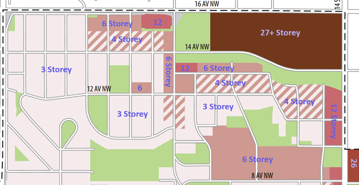
The biggest changes are in Scale. As expected, they added twelve storey areas to our community, including in places where currently there are single-family homes. They changed the area between 14 Street and 15 Street NW from three and four storey to twelve storey, even though the access to the area north of 11 Ave NW is very poor (from the lane off the north end of 15 Street), and the area between 11 Ave and 10 Ave is very sloped. None of these lots would have practical access off 14 Street, and the burden of traffic, parking etc. will fall to 15 Street. There are also issues with large structures in these locations, as the Sears gas plume is beneath this area. Comments about these practical concerns were not heeded in the “conversation series”, only the distance to the Lions Park and SAIT stations seemed to matter. Vistas for many in HH could be blocked by this huge change. 26 storeys are now proposed for all of the Riley Park Village (old Grace Hospital) site, adding to this issue. Twelve storey was also added to the Seventh Day Adventist Church site area and maintained on the Highlander Plaza.
Six storeys are maintained on the north side of 13 Ave NW, over Lions Park Plaza, and below the escarpment in HH, where it further impedes vistas and discourages the retention of the affordable Cedar Brae complex. Six storeys have been added to 19 Street NW between 14 and 12 Ave, and also to the west side of 18A Street, and over the plaza near Green Park. It has also been added on the north half of the blocks on 20A Street, 21 Street, and 21A Street, between 14 and 16 Ave, where we have repeatedly pointed out the poor egress from the one-way lane. There was nothing but three storeys in these BH locations before this revision.
Four storeys have been added to the southern half of the same blocks on 20A Street, 21 Street, and 21A Street, and also on the 20 Street cul-de-sac in BH. It is also added along the north side of 12 Ave both near the commercial in BH and throughout HH, and also in the whole area north of 11 Ave, on 15, 16, and 16A Streets in eastern HH. Please look carefully at the map above, or online, to see how these changes affect your home.
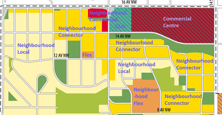
The Urban Form map has also changed. The main change is a much larger area of ‘Neighbourhood Connector’ over much of HH and BH. Connector is described as being “along higher activity, predominantly residential, streets”, and yet City Administration has extended it over an even larger portion of the quiet residential roads of our community. The main implication of the Connector designation is that H-GO (extra tall (12 m) and extra dense row houses) are allowed in this area. The Urban Form map extends the concept of permitted H-GO over roughly half of our community, intensifying the already passed R-CG (regular 11 m tall row houses). This map also changes the Highlander and Lions Park Plazas to Neighbourhood Commercial (from Neighbourhood Flex), which now allows “the widest range of commercial uses”, and broadens what these lands might be used for.
This proposal has a very large area of apartments with limited setbacks, limited room for trees, significant traffic burden on quiet streets, significant change in privacy and noise, and significant burden on infrastructure, all imposed on a currently grade-oriented single-family community. The Community Association has spoken about reasonable compromise and the effects on our community. We are not expecting “no change”, but very little of our concerns have been heard (even simple ones, e.g. indoor access to shopping on the Mall site is still not well addressed), and our ideas for mitigation of impacts have been dismissed (e.g. well-designed semi-detached infills to blend in with existing homes). And this is not a matter of equity – consideration of the existing communities needs to apply to all existing communities, whether modest or more upscale, that pre-existed the LRT construction and these plans. Whilst we cannot expect “no change”, no-one should experience dramatic fundamental change to the nature of their communities either.
This concept that existing stable communities should be respected is in the Municipal Development Plan (MDP) and Transit Oriented Development (TOD) guidelines, and up to now it was well understood. The MDP says “ensure infill development complements the established character of the area and does not create dramatic contrasts in the physical development pattern”. There are many other similar statements in both the MDP and TOD, but clearly the proposed LAP is ignoring the MDP and TOD and is a very dramatic change. In addition, the City is also working on replacing the Municipal Development Plan with the “Calgary Plan”, and these concepts of considering context and respecting the citizens and communities that are already there do not appear to be included anymore… Personally, I think it is grossly unfair and unreasonable to ignore context like this – we cannot get in a time machine and choose a different neighbourhood into which to invest our hearts and finances! We need to step up our lobby about context and respect – that everyone counts, both current and future residents, and existing communities should not be thrown under the bus!
The referral motion from Council had a second clause that instructs revisions to “focus on planning for growth and change that integrates multi-modal mobility and improved citizen experience of land use development that enables walkability, community connections, and integrated commercial and residential uses for all ages and abilities”, and several speakers in October commented that the Mobility Study was not well incorporated into the LAP. However, the revised LAP does not appear to make significant changes to address this second clause. The only interesting change in our area is the promotion of “a direct and accessible pedestrian and cycling connection from the Riley Park Village to the SAIT LRT” and “a grade separated crossing north of 10 Ave NW across 14 Street NW”. These ideas more support the bigger built forms they hope to see on 14 Street, rather than supporting pedestrian flow from our community to downtown and from Hillhurst to North Hill Centre. We have suggested a crossing closer to 8 Ave to best facilitate pedestrian routes; to meet both goals, the crossing would need to be no further north than 10 Ave. Councillor Wong has also been lobbying to add better descriptions of the community context to the LAP, but Administration has not changed this aspect at all.
The revised LAP already passed through the Infrastructure and Planning Committee on January 8. It was another very disappointing day. Many residents of HH-BH, Hillhurst, and West Hillhurst spoke of not being heard, the lack of engagement, and not being aware of this new plan, specific concerns about inappropriate scales and policies in the new revision, issues with significant shadowing of parks, lack of consideration of contaminated sites, parking and traffic issues, mobility not being properly addressed, etc. But none of it was heeded, and the respectful compromise we’ve asked for is just not there. Yet, developer representatives and activists spoke and were happy with the new plan.
There will be a final public hearing before council shortly on the Riley Local Area Plan, tentatively scheduled for March 4. Please watch for communication of the public hearing, and consider expressing your view, by speaking, writing, or both. Community members can also express their opinions directly to council ([email protected], [email protected], our Councillor Terry Wong, and similarly for the rest of the 14 councillors – [email protected] etc.). We can discuss and answer questions at [email protected].
Beth Atkinson
Director – Land Use, Hounsfield Heights – Briar Hill Community Association
Click here to the Briar Hill Community News home page for the latest Briar Hill community updates.
Click here to the Hounsfield Heights-Briar Hill Community News home page for the latest Hounsfield Heights-Briar Hill community updates.