
City council is considering the approval of the new the Riley Local Area Plan (LAP) on March 4 – if you receive this newsletter before then, please consider participating in the public hearing and expressing your views. There may be further lobbyists that push for yet more apartments permitted in our community, so we do need to continue to express our concerns and message of reasonable compromise to council. Community members can also express their opinions directly to council ([email protected], [email protected], our Councillor Terry Wong, and similarly for the rest of the 14 councillors – [email protected] etc.). We can discuss and answer questions at [email protected].

The latest proposal can be found here: https://engage.calgary.ca/Riley/Realize, click on their “Proposed Riley Communities Local Area Plan click here”, for the whole LAP document, and scroll down for an interactive scanner that highlights the striking comparison of the Scale Map and Urban Form Map, from May 2024 to December 2024.
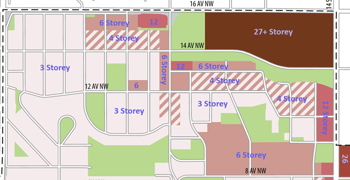
Note how the city now has twelve storey areas to our community, including in places where currently there are single-family homes. They changed the area between 14 Street and 15 Street NW from three and four storey to twelve storey, even though the access to the area north of 11 Ave NW is very poor (from the lane off the north end of 15 Street), and the area between 11 Ave and 10 Ave is very sloped. None of these lots would have practical access off 14 Street, and the burden of traffic, parking etc. will fall to 15 Street. There are also issues with large structures in these locations, as the Sears gas plume is beneath this area. Comments about these practical concerns were not heeded in the “conversation series”, only the distance to the Lions Park and SAIT stations seemed to matter. Vistas for many in HH could be blocked by this huge change. 26 Storeys is now proposed for all of the Riley Park Village (old Grace Hospital) site, adding to this issue. Twelve storey was also added to the Seventh Day Adventist Church site area and maintained on the Highlander Plaza.
Six storeys are planned on the north side of 13 Ave NW, over Lions Park Plaza, and below the escarpment in HH, where it further impedes vistas and discourages the retention of the affordable Cedar Brae complex. Six storeys have been added to 19 Street NW between 14 and 12 Ave, and also to the west side of 18A Street, and over the plaza near Green Park. It has also been added on the north half of the blocks on 20A Street, 21 Street, and 21A Street, between 14 and 16 Ave, where we have repeatedly pointed out the poor egress from the one-way lane. There was nothing but three storeys in these BH locations before this latest revision.
Four storeys have been added to the southern half of the same blocks on 20A Street, 21 Street, and 21A Street, and also on the 20 Street cul-de-sac in BH. It is also added along the north side of 12 Ave both near the commercial in BH and throughout HH, and also in the whole area north of 11 Ave, on 15, 16, and 16A Streets in eastern HH. Please look carefully at the map above, or online, to see how these changes affect your home.
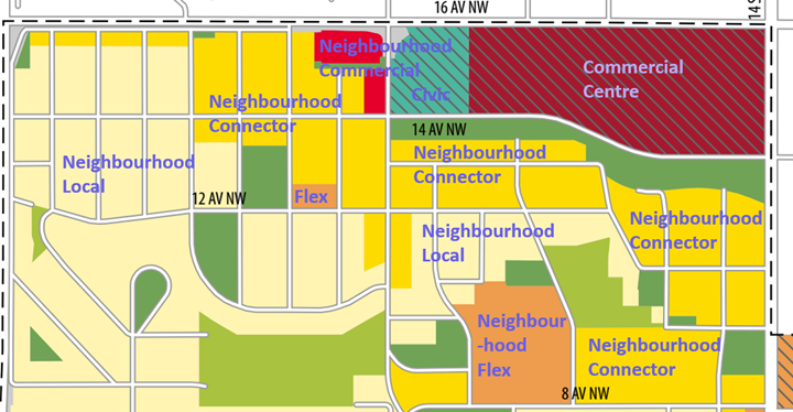
The Urban Form map now has a large area of ‘Neighbourhood Connector’ over much of HH and BH. Connector – this Urban Form is described as being “along higher activity, predominantly residential, streets”, and the main implication of the Connector designation is that H-GO (extra tall (12 m) and extra dense row houses) are allowed in this area. The Urban Form map now extends the concept of permitted H-GO over roughly half of our community, intensifying the already passed R-CG (regular 11 m tall row houses). This map also changes the Highlander and Lions Park Plazas to Neighbourhood Commercial (from Neighbourhood Flex), which now allows “the widest range of commercial uses”, and broadens what these lands might be used for.
This proposal has a very large area of permitted apartments with limited setbacks, limited room for trees, significant traffic burden on quiet streets, significant change in privacy and noise, and significant burden on infrastructure, all imposed on a currently grade-oriented single-family community. The Community Association has spoken about reasonable compromise and the effects on our community. We are not expecting “no change”, but very little of our concerns have been heard (even simple ones, e.g. indoor access to shopping on the Mall site is still not addressed), and our ideas for mitigation of impacts have been dismissed (e.g. well-designed semi-detached infills to blend in with existing homes).
This concept that existing stable communities should be respected is in the Municipal Development Plan (MDP) and Transit Oriented Development (TOD) guidelines, and up to now it was well understood. The MDP says “ensure infill development complements the established character of the area and does not create dramatic contrasts in the physical development pattern”. There are many other similar statements in both the MDP and TOD, but clearly the proposed LAP is ignoring the MDP and TOD and is a very dramatic change. Also, consideration of the existing communities needs to apply to all existing communities, whether modest or more upscale, that pre-existed the LRT construction and these plans. Personally, I think it is grossly unfair and unreasonable to ignore context like this – we cannot get in a time machine and choose a different neighbourhood into which to invest our hearts, hard work, and finances! Everyone counts, both current residents and future residents who would appreciate our unique community, and existing communities should not be thrown under the bus!
Beth Atkinson
Director – Land Use, Hounsfield Heights–Briar Hill Community Association
Click here to the Briar Hill Community News home page for the latest Briar Hill community updates.
Click here to the Hounsfield Heights-Briar Hill Community News home page for the latest Hounsfield Heights-Briar Hill community updates.